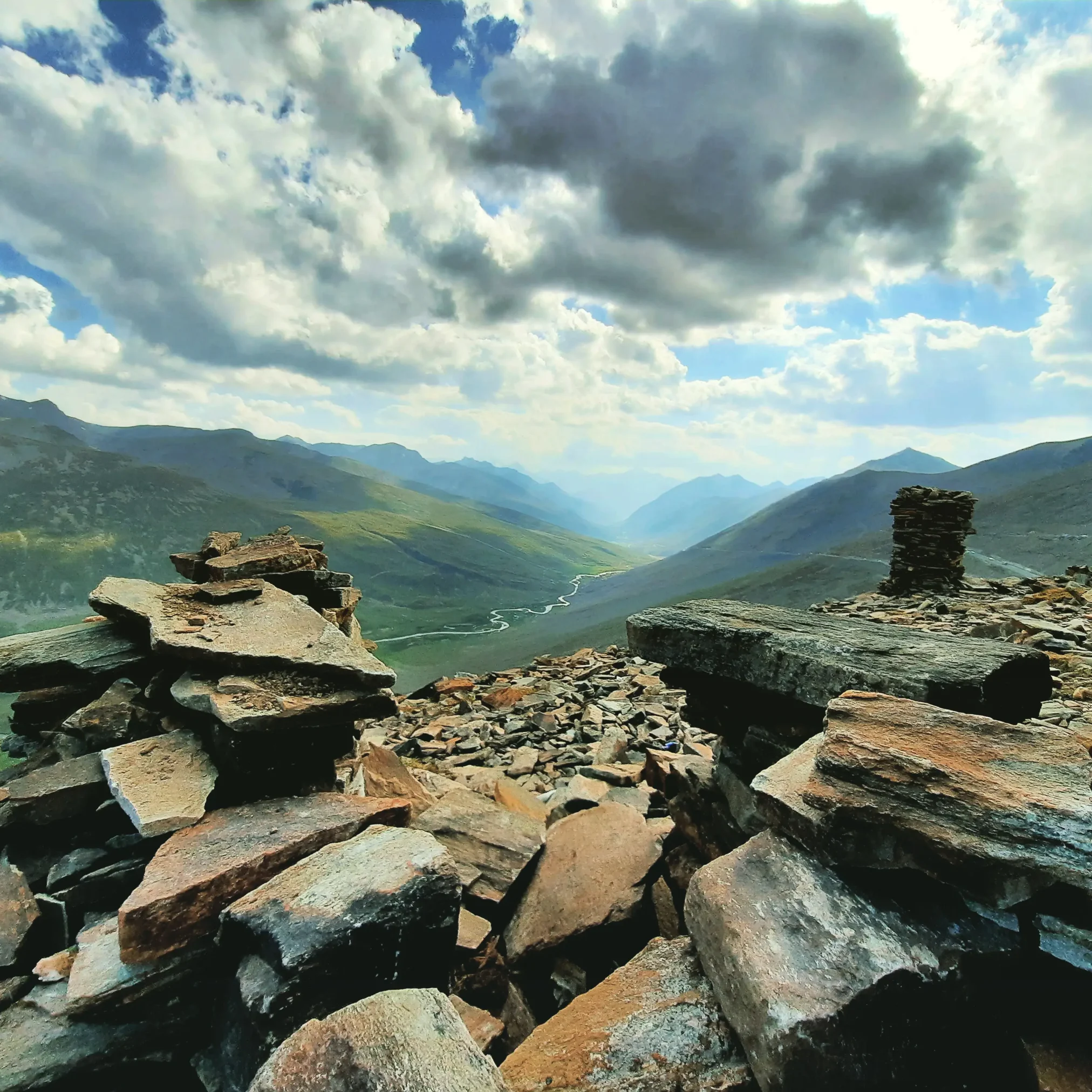
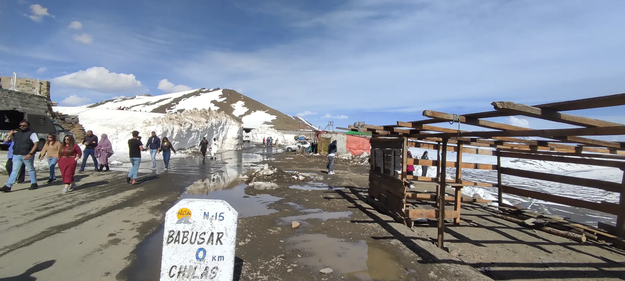
Introduction to Babusar Top – Pakistan’s Crown Jewel of Natural Beauty
Pakistan is a country blessed with extraordinary natural landscapes. From vast river systems to fertile agricultural lands and four distinct seasons, the country offers a remarkable blend of natural diversity. However, the northern region of Pakistan stands out as one of the most breathtaking areas in the entire world.
Among the countless scenic destinations in northern Pakistan, Babusar Top holds a very special place.
Babusar Top Height
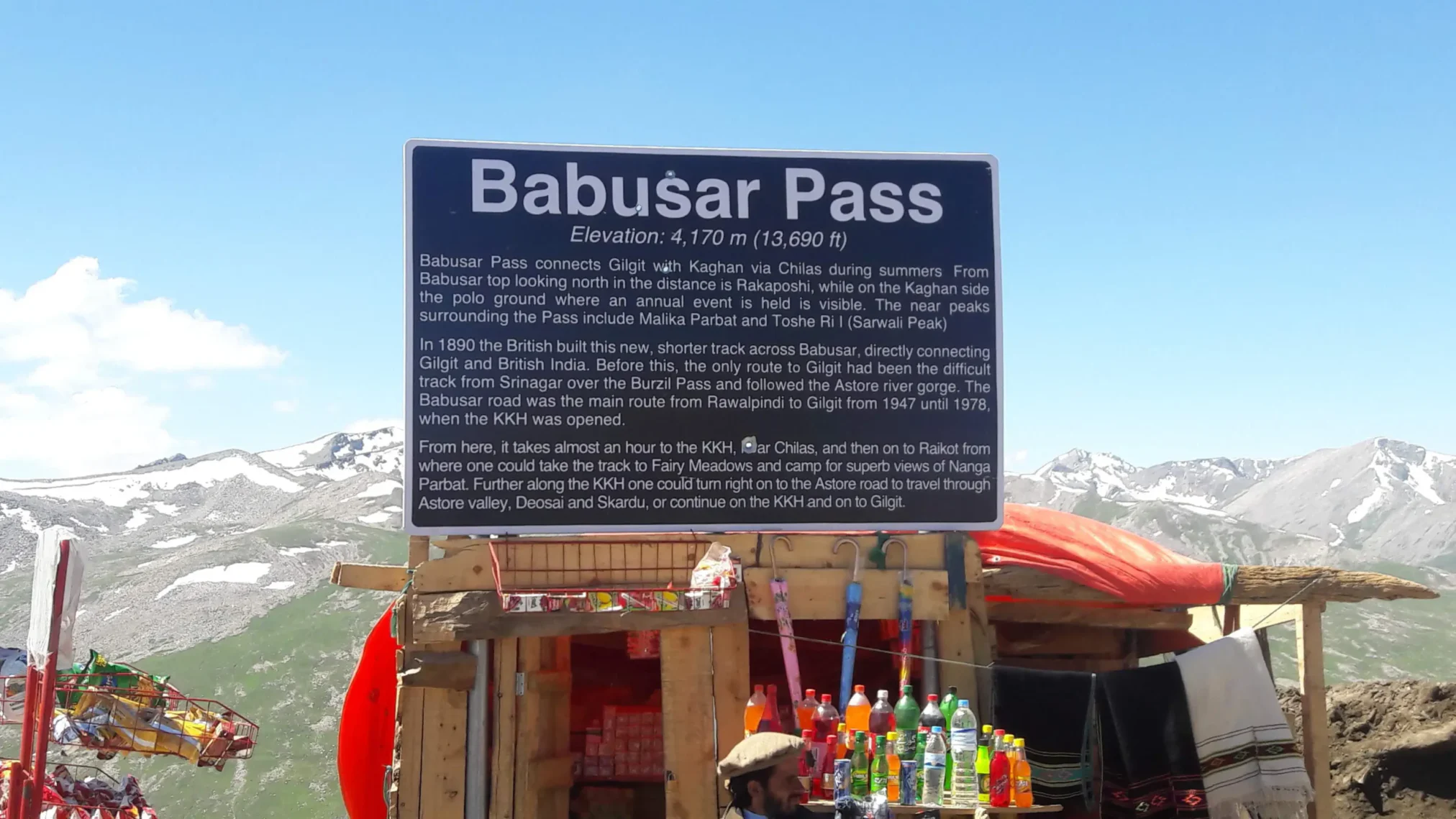
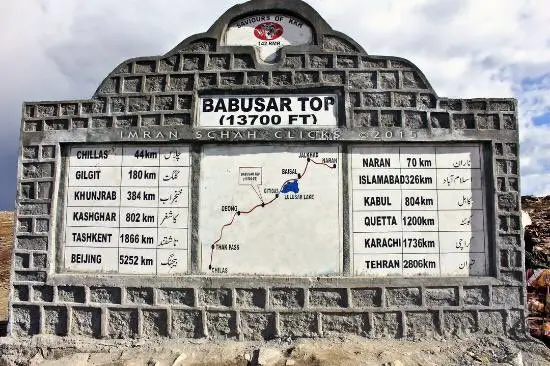
Babusar Top Height is 4,173 meters (13,691 feet) above sea level, Babusar Top is one of the highest mountain passes accessible by road in Pakistan. It serves as a vital link between Kaghan Valley and Chilas, connecting travelers to famous northern destinations such as Gilgit, Hunza Valley, and Skardu.
Every summer, thousands of travelers journey through this mountain pass to experience its incredible landscapes, towering peaks, alpine meadows, crystal-clear lakes, and dramatic winding roads.
Babusar Top is not just a mountain pass; it is an unforgettable adventure that combines:
- High-altitude road trips
- Spectacular Himalayan scenery
- Unique wildlife and biodiversity
- Cultural experiences
- Thrilling photography opportunities
For nature lovers, road trip enthusiasts, and adventure seekers, Babusar Top offers a journey unlike any other.
The Beauty of Northern Pakistan
The northern areas of Pakistan are home to some of the world’s most spectacular mountain ranges, including the Himalayas, Karakoram, and Hindu Kush. These ranges contain some of the highest peaks on Earth, including Nanga Parbat, which stands at 8,126 meters, making it the ninth highest mountain in the world.
The region surrounding Babusar Top showcases the dramatic beauty of these mountain systems, where snow-covered peaks, lush valleys, and alpine meadows create landscapes that appear almost surreal. Travelers often describe their experience of reaching Babusar Top as standing “above the clouds,” where cool mountain winds and floating clouds create a magical atmosphere.
Where is Babusar Top Located?
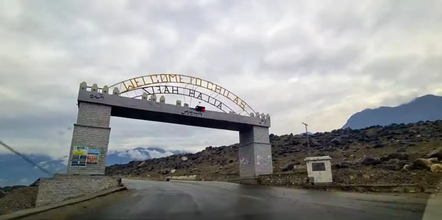
Babusar Top is located in the upper region of Kaghan Valley in the Mansehra District province. The mountain pass lies along the N-15 Highway, which connects the famous tourist town of Naran with Chilas.
Key Distances
| Location | Distance to Babusar Top |
|---|---|
| Islamabad | ~300 km |
| Naran | ~70–120 km |
| Chilas | ~130 km |
| Gilgit | ~200 km |
Travelers typically reach Babusar Top during a road trip through Kaghan Valley while heading toward Gilgit-Baltistan.
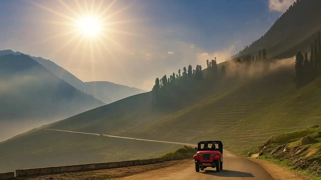
The Journey to Babusar Top
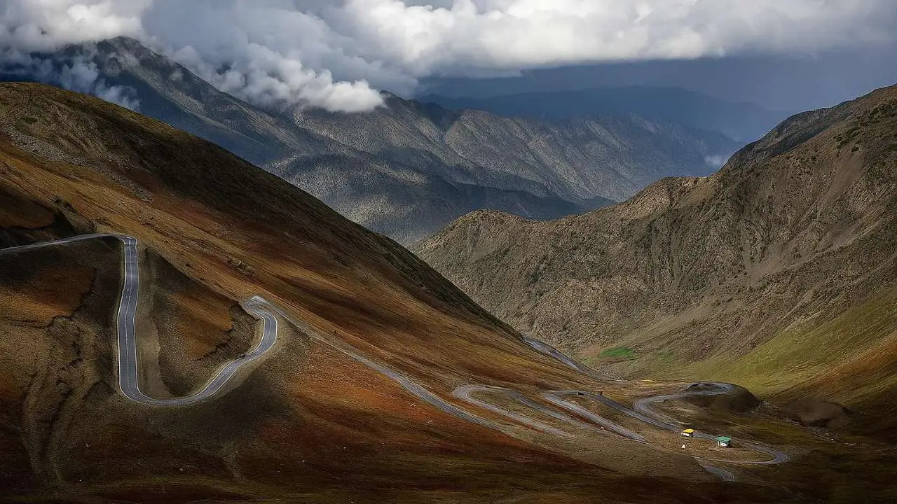
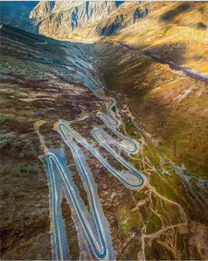
The road journey to Babusar Top is considered one of the most scenic drives in Pakistan.
Starting from Balakot, travelers pass through lush valleys, flowing rivers, and picturesque villages before reaching Naran, which serves as the main tourist hub of Kaghan Valley. From Naran, the road gradually climbs higher into the mountains, passing through several stunning locations including:
- Batakundi
- Jhalkad
- Lulusar Lake
As travelers approach Babusar Top, the road becomes increasingly dramatic, featuring steep ascents, hairpin turns, and breathtaking panoramic viewpoints.
Why Babusar Top is Famous
Babusar Top is famous for several reasons that make it one of Pakistan’s most iconic tourist destinations.
1. One of the Highest Road Passes in Pakistan
At 4,173 meters, Babusar Top is among the highest mountain passes accessible by vehicles.
2. Spectacular Himalayan Views
From the summit, travelers can enjoy panoramic views of the Himalayas, including the majestic Malika Parbat.
3. Gateway to Gilgit-Baltistan
The pass serves as a connecting route to the northern regions of Pakistan including Hunza Valley and Skardu.
4. Photography Paradise
The winding roads, alpine meadows, glaciers, and lakes make Babusar Top a paradise for photographers.
5. Adventure Road Trip Destination
The challenging mountain road attracts adventure lovers who enjoy scenic driving routes.
Google Review
⭐⭐⭐⭐⭐
“Absolutely breathtaking views. The drive from Naran to Babusar Top is one of the most scenic road trips in Pakistan.” — Traveler Review
⭐⭐⭐⭐⭐
“One of the best places for photography in northern Pakistan. Every turn on the road offers a new stunning view.” — Adventure Photographer
The Geography of Babusar Top and Kaghan Valley
The region surrounding Babusar Top lies in the upper portion of Kaghan Valley, a valley famous for its alpine scenery, rivers, forests, and glacial lakes. Kaghan Valley stretches approximately 155 kilometers from Balakot to the high-altitude Babusar Pass. The valley forms part of the mountainous terrain of Mansehra District.
This region is characterized by:
- Snow-covered peaks
- Vast alpine meadows
- Dense pine forests
- Glacier-fed rivers
- High mountain passes
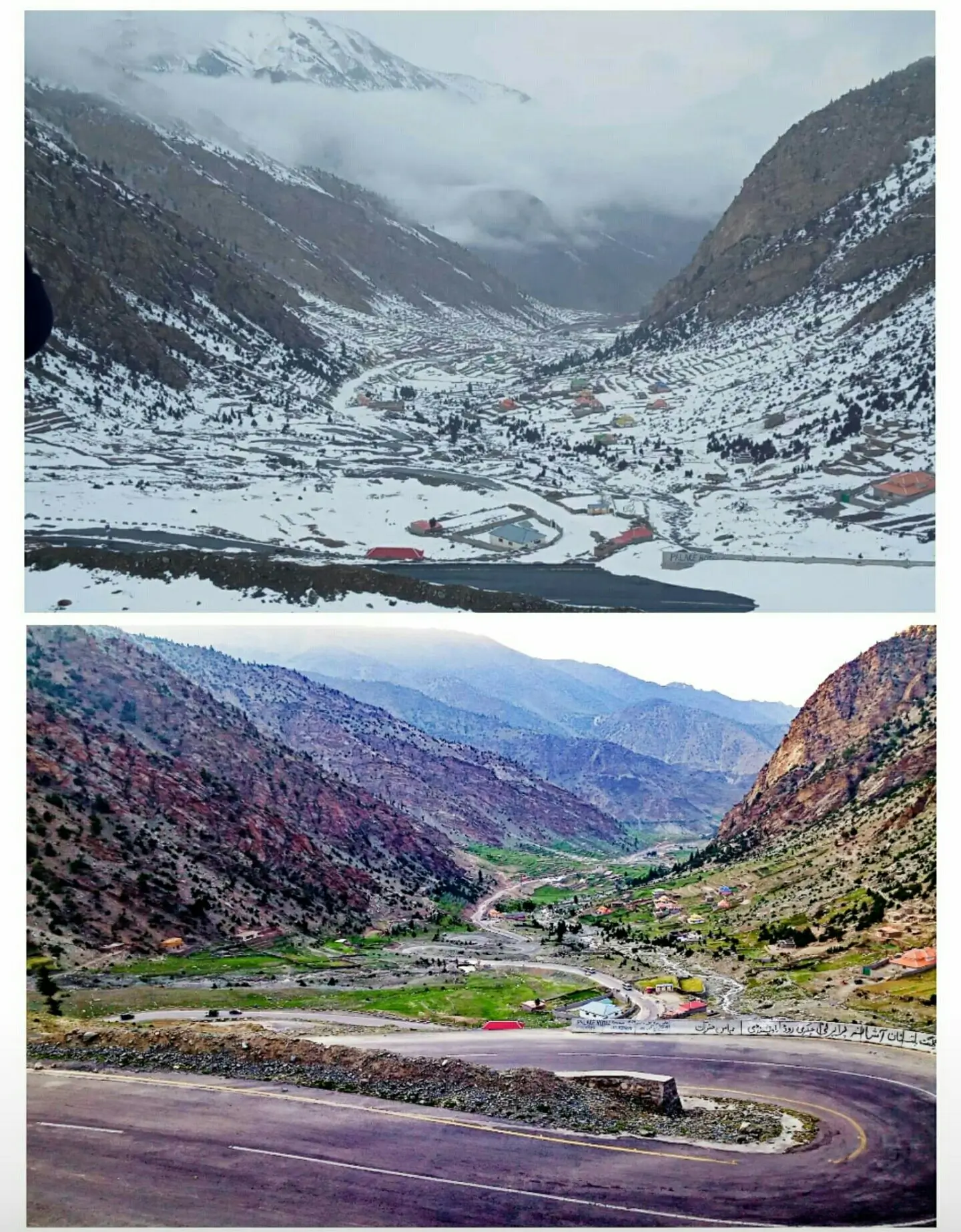
The valley gradually rises in elevation as travelers move north from Balakot toward Babusar Top. At the northern end of the valley lies Babusar Top, which connects Kaghan Valley with Chilas, opening the gateway to the famous northern areas of Pakistan.
Mountain Systems Surrounding Babusar Top
The Babusar region lies at the meeting point of several great mountain systems.
These include:
- Himalayas
- Karakoram
- Hindu Kush
These mountain ranges contain some of the highest peaks on Earth and shape the dramatic landscape visible from Babusar Top. From the summit of Babusar Pass, travelers can witness an incredible panoramic view of snow-covered mountains stretching across the horizon.
On a clear day, some travelers even catch distant glimpses of Nanga Parbat, one of the most famous mountains in the world. Standing at 8,126 meters, Nanga Parbat is often referred to as the “Killer Mountain” due to its challenging climbing conditions.
Malika Parbat – The Queen of the Mountains
One of the most stunning peaks visible from Babusar Top is Malika Parbat. Malika Parbat translates to “Queen of the Mountains.” Key facts about Malika Parbat:
- Height: approximately 5,290 meters (17,356 feet)
- Highest peak in Kaghan Valley
- Part of the Himalayan mountain range
- Popular destination for mountaineers
The peak dominates the skyline of the region and can often be seen towering above the valley during clear weather. The view of Malika Parbat from Babusar Top is considered one of the most spectacular sights in the entire Kaghan Valley.
The Alpine Landscape of Babusar Region
The landscape around Babusar Top changes dramatically as travelers ascend from lower altitudes.
Lower Valley Landscape
In the lower portions of Kaghan Valley near Balakot and Naran, the terrain features:
- Dense forests
- River valleys
- Agricultural land
- Small villages
These areas support farming and local communities due to the relatively mild climate.
Mid-Elevation Landscape
As travelers move toward Naran, the landscape becomes more mountainous. Here visitors encounter:
- Steep valleys
- Pine forests
- Glacier streams
- Meadows and pastures
These scenic areas attract tourists throughout the summer season.
High Altitude Landscape
Beyond Naran, the terrain becomes dramatically alpine. In the higher regions near Babusar Top, travelers witness:
- Rocky mountains
- Snow-covered peaks
- Glacial lakes
- Open grasslands
Vegetation becomes sparse due to the extreme altitude and harsh Babusar top weather conditions. However, the high-altitude meadows create beautiful green landscapes during the summer months.
The Role of Glaciers in the Region
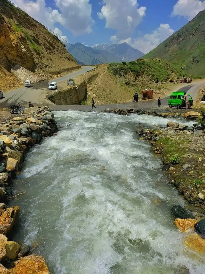
Glaciers play a critical role in shaping the geography of the Babusar region. Many of the rivers and lakes in Kaghan Valley originate from melting glaciers in the surrounding mountains. These glaciers feed the famous Kunhar River, which flows through the entire valley. The Kunhar River is known for:
- crystal clear water
- trout fish
- fast mountain currents
- scenic riverside views
The river adds immense beauty to the valley and is a major attraction for visitors.
Alpine Meadows and Pastures
The Babusar region contains numerous alpine meadows that come alive during summer. These meadows provide grazing grounds for livestock belonging to local nomadic communities. During warmer months, Gujjar and nomadic herders bring their sheep and goats to these high pastures. Visitors traveling toward Babusar Top often witness:
- large flocks of sheep
- traditional shepherd huts
- grazing goats
- pastoral landscapes
These scenes offer a glimpse into the traditional lifestyle of mountain communities.
Forests of Kaghan Valley
Although Babusar Top itself lies above the tree line, the surrounding regions contain rich forests. The forests of Kaghan Valley mainly consist of:
- Pine trees
- Oak trees
- Cedar
- Fir trees
These forests provide habitat for wildlife and help maintain the ecological balance of the region. However, human activity and deforestation have impacted some forest areas. Environmental experts often stress the importance of conservation in this fragile mountain ecosystem.
Natural Waterfalls and Streams
Another defining feature of the Babusar region is its numerous waterfalls and streams. Glacier meltwater flows down the mountains, creating beautiful waterfalls along the road to Babusar Top. Travelers driving along the N-15 Highway often stop at roadside streams to enjoy the cold mountain water and scenic surroundings. These streams contribute to the unique charm of the road journey through Kaghan Valley.
Unique High-Altitude Environment
Because Babusar Top lies at such a high elevation, the environment here is very different from the lower valleys. Key characteristics include:
- thin air
- low oxygen levels
- cold temperatures even in summer
- strong mountain winds
The high-altitude environment creates a dramatic and surreal atmosphere that attracts adventure travelers and photographers. Many visitors describe the experience of standing at Babusar Top as “being above the clouds.”
Why Geography Makes Babusar Top Unique
The geography of Babusar Top combines multiple natural features rarely found together in one location:
- towering Himalayan peaks
- glacier-fed rivers
- alpine lakes
- lush meadows
- scenic mountain roads
This rare combination is what makes Babusar Top one of the most remarkable destinations in Pakistan’s tourism landscape. For travelers exploring northern Pakistan, the geography alone makes Babusar Top an unforgettable experience.
Famous Lakes and Tourist Attractions Around Babusar Top
The route from Naran to Babusar Top is not just a road—it is an entire journey through nature’s wonders. Along this route, visitors encounter:
- crystal-clear alpine lakes
- breathtaking waterfalls
- lush green meadows
- forest landscapes
- thrilling jeep tracks
These attractions transform a simple road trip into one of the most memorable travel experiences in Pakistan.
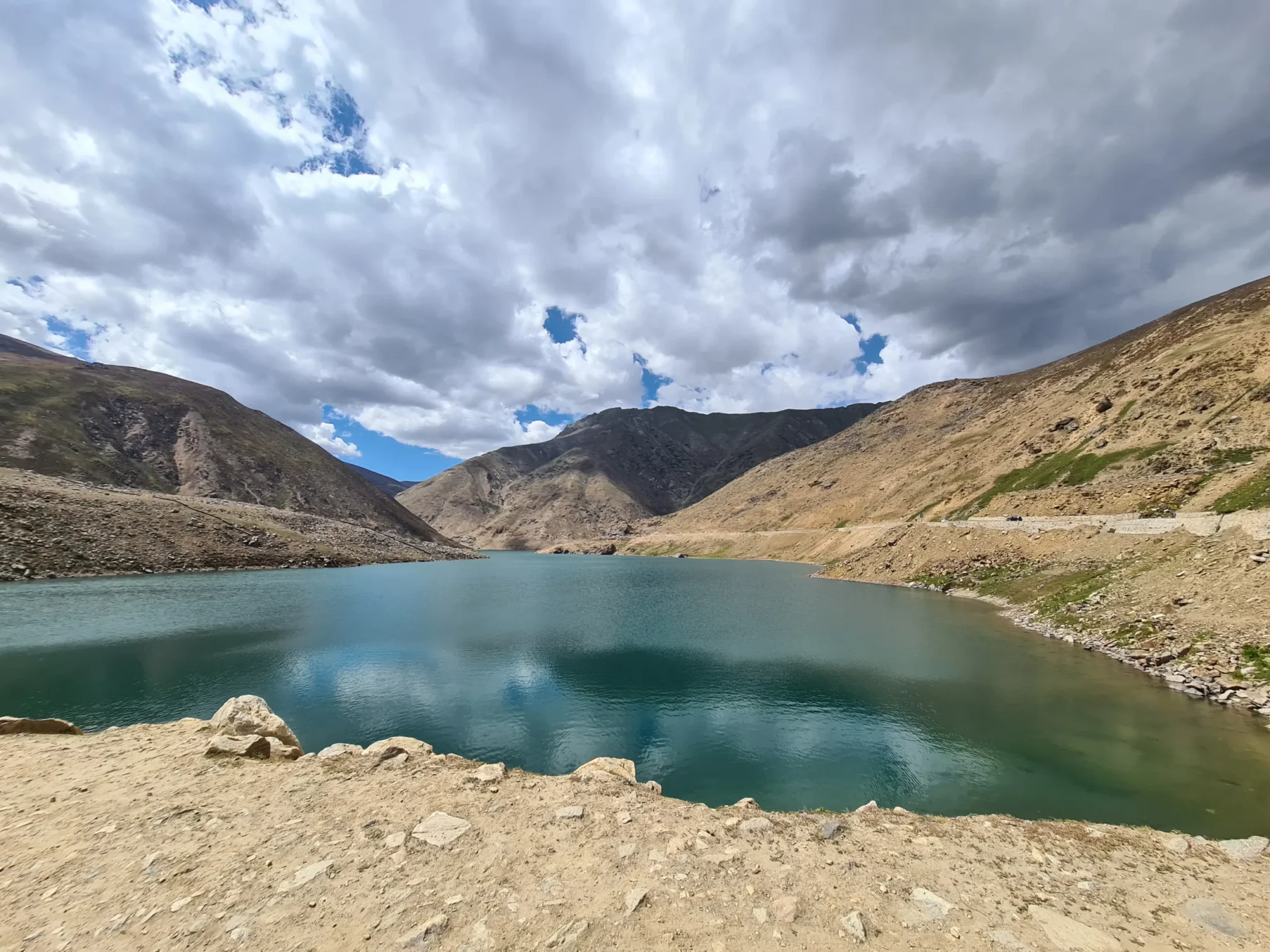
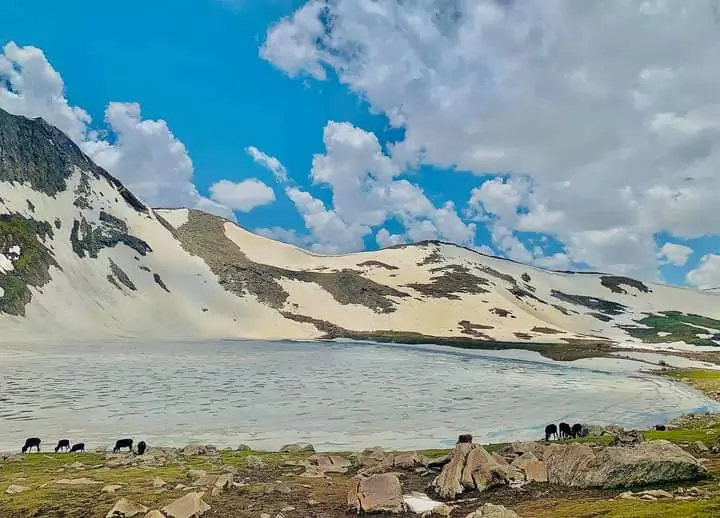
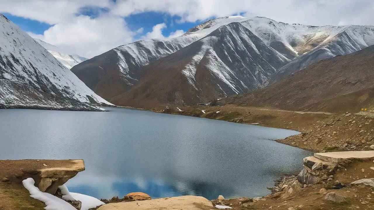
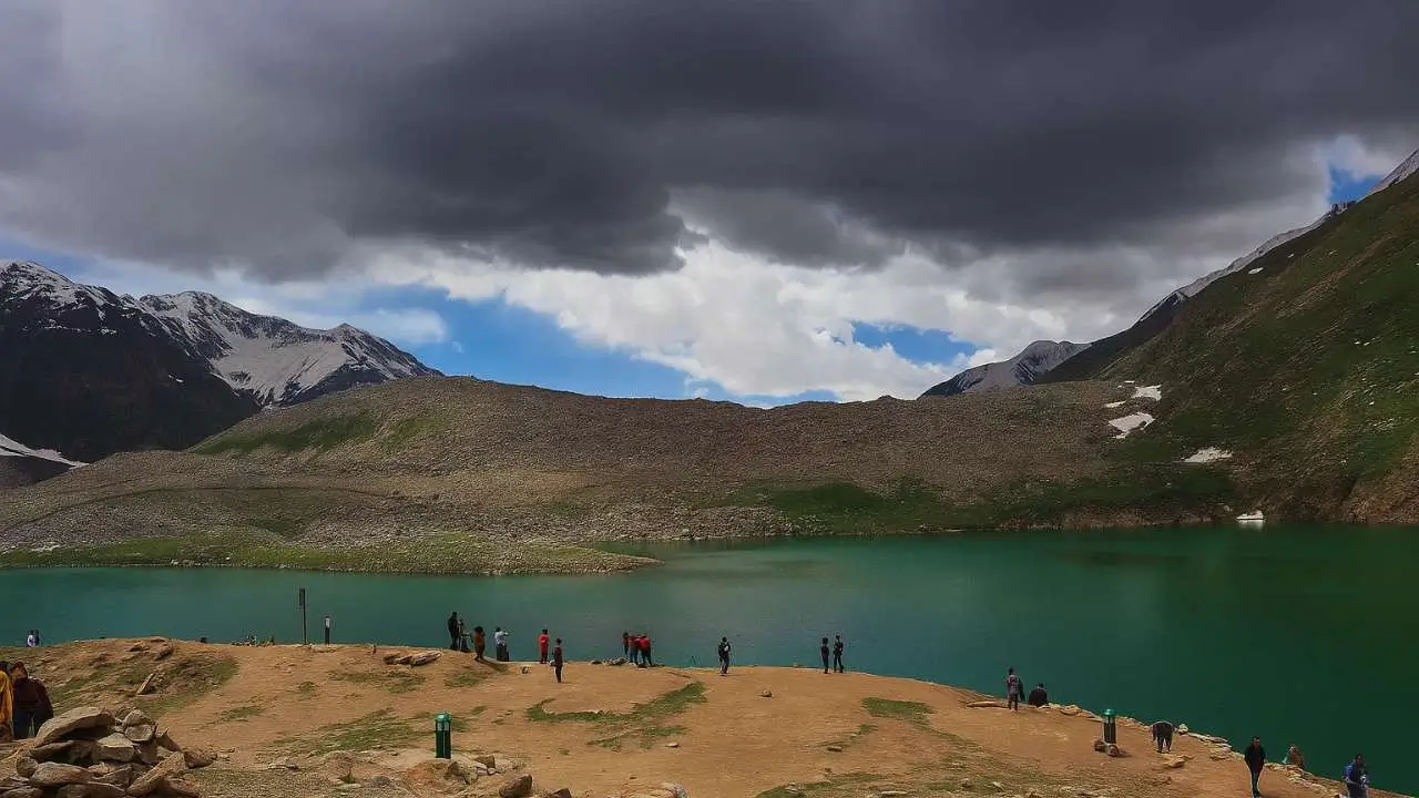
Lulusar Lake – The Jewel of Kaghan Valley
One of the most stunning natural attractions along the Babusar route is Lulusar Lake. Located at an altitude of approximately 3,410 meters (11,190 feet), Lulusar Lake is the largest natural lake in Kaghan Valley.
Why Lulusar Lake is Famous
The lake is surrounded by snow-covered mountains and lush alpine landscapes, creating a breathtaking reflection of the surrounding peaks in its clear waters. Key features of Lulusar Lake:
- Crystal-clear glacial water
- Stunning mountain reflections
- Scenic photography opportunities
- Peaceful picnic locations
- Cool and refreshing climate
During summer months, travelers often stop here to relax, take photos, and enjoy the tranquil beauty of the area. The lake is also the primary source of the Kunhar River, one of the most important rivers flowing through Kaghan Valley.
Lake Saiful Malook – The Legendary Fairy Lake
Another iconic attraction near Babusar Top is Lake Saiful Malook. Located about 8 kilometers from Naran, this magical lake is considered one of the most beautiful alpine lakes in Pakistan. The lake sits at an elevation of 3,224 meters (10,578 feet) and is surrounded by towering mountains including Malika Parbat.
Folklore and Cultural Significance
Lake Saiful Malook is famous for a legendary romantic story involving a Persian prince named Saiful Malook and a fairy princess called Badri Jamala. According to folklore, the prince fell in love with the fairy princess at this lake. This enchanting story has made the lake a place of mystery and romance, attracting visitors and storytellers for generations.
Activities at Saiful Malook Lake
Visitors can enjoy many activities here, including:
- Jeep rides from Naran
- Horse riding around the lake
- Photography of Malika Parbat
- Camping near the lakeshore
- Trekking in surrounding mountains
The lake is particularly popular among photographers due to its dramatic scenery and reflections of snow-covered peaks.
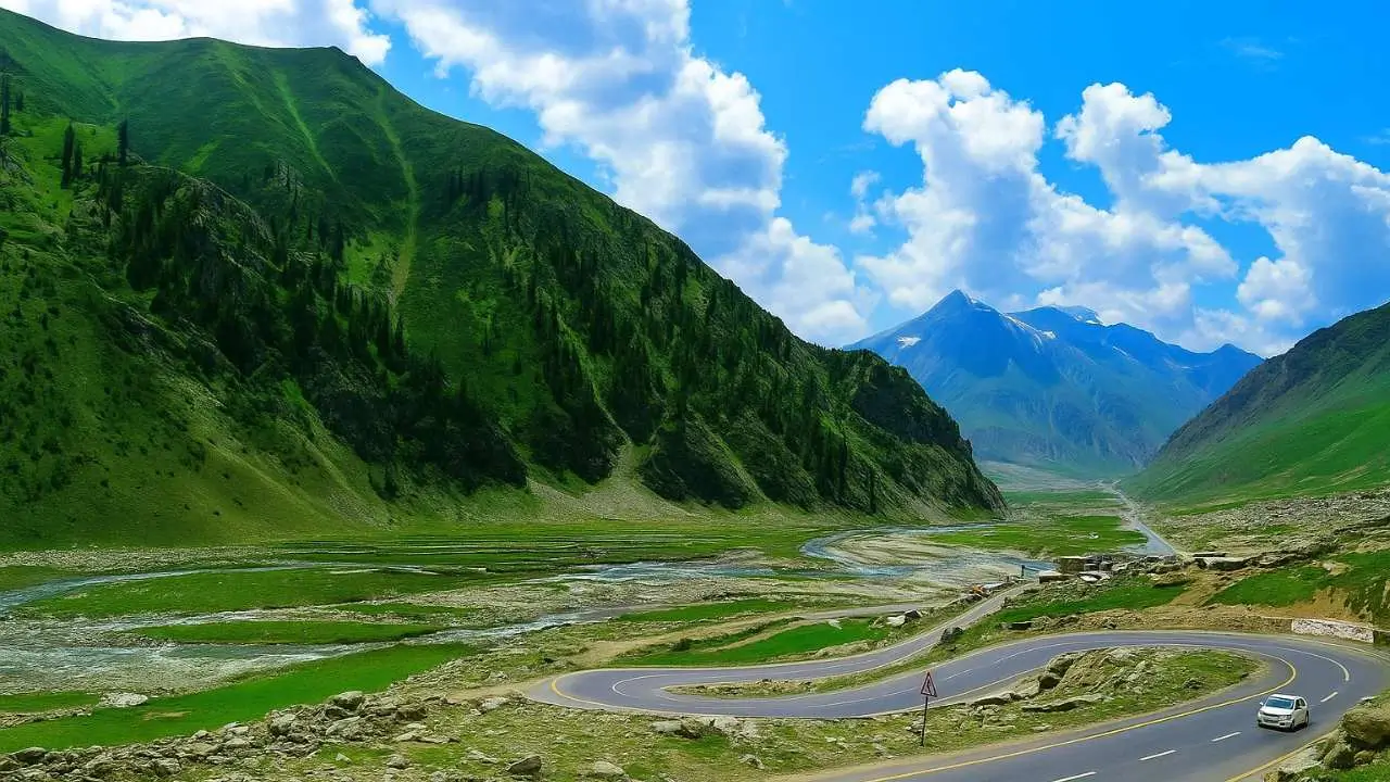
Lulusar–Babusar Route – One of Pakistan’s Most Scenic Roads
The drive between Naran and Babusar Top along the N-15 Highway is widely considered one of the most scenic road trips in Pakistan. Travelers encounter:
- winding mountain roads
- glacier streams
- waterfalls
- lush green valleys
- dramatic mountain scenery
Each turn of the road reveals a new panoramic landscape. Because of this beauty, the route is a favorite for:
- travel vloggers
- photographers
- road trip enthusiasts
- international tourists
Batakundi – The Hidden Gem of Kaghan Valley
Located a short distance beyond Naran is the beautiful mountain village of Batakundi. This peaceful town offers stunning views of surrounding mountains and rivers. Batakundi has become increasingly popular among travelers seeking a quieter alternative to Naran.
Attractions of Batakundi
Visitors to Batakundi enjoy:
- waterfalls and streams
- scenic landscapes
- affordable hotels
- fresh mountain air
- views of Tiger Peak
The village provides a perfect resting point for travelers heading toward Babusar Top.
Jhalkad – The Gateway to Babusar Top
Another important location along the Babusar route is Jhalkad. Jhalkad serves as a base camp for travelers exploring nearby destinations such as:
- Dudipatsar Lake
- Noori Top
- Babusar Pass
Because Babusar Top has extremely harsh weather conditions, permanent settlements are rare at higher altitudes. Jhalkad provides the nearest habitable area for travelers. During the summer season, many tourists stay here before continuing their journey toward Babusar Top.
Dudipatsar Lake – The White Pearl Lake
One of the most beautiful hidden lakes near Babusar Top is Dudipatsar Lake. The name Dudipatsar means “White Mountain Lake.” This lake lies inside the Lulusar-Dudipatsar National Park.
Features of Dudipatsar Lake
- crystal-clear blue water
- surrounded by snow-covered peaks
- located at approximately 3,800 meters altitude
- accessible by trekking routes
Because reaching the lake requires trekking, it remains less crowded compared to Saiful Malook. For adventure travelers, Dudipatsar Lake is considered one of the most rewarding trekking destinations in Pakistan.
Waterfalls of Kaghan Valley
The Babusar region is rich in natural waterfalls created by melting glaciers and mountain streams. One of the notable waterfalls mentioned by travelers is Sooch Waterfall. These waterfalls create picturesque roadside stops where travelers can relax and enjoy the sound of flowing water. Waterfalls add to the magical charm of the road journey toward Babusar Top.
Photography Paradise for Travelers
For photography enthusiasts, the Babusar region offers endless opportunities. Some of the best photography locations include:
- mountain viewpoints along the Babusar road
- alpine lakes such as Lulusar and Saiful Malook
- glacier streams and waterfalls
- sunrise and sunset at Babusar Top
- snow-covered peaks in the distance
Professional photographers often visit the region specifically to capture these breathtaking landscapes.
Meadows, Forests, and Adventure Destinations Around Babusar Top
The Babusar region is not only famous for lakes and mountain passes. The valley is also home to breathtaking meadows, forests, and adventure destinations that attract travelers seeking nature, trekking, and unforgettable landscapes.
Shogran – The Gateway to Alpine Beauty
One of the most famous tourist destinations in Kaghan Valley is Shogran. Located approximately 30 kilometers from Balakot, Shogran sits at an elevation of around 7,749 feet above sea level. This charming hill station is surrounded by lush green hills, dense pine forests, and breathtaking mountain views.
Why Shogran is Popular
Shogran has become a favorite destination for tourists due to:
- cool and pleasant summer climate
- panoramic views of surrounding mountains
- comfortable hotels and resorts
- access to nearby trekking destinations
Many travelers visiting Babusar Top begin their journey by staying in Shogran to enjoy the beauty of Kaghan Valley. During winter months, Shogran transforms into a snowy paradise where visitors enjoy the peaceful atmosphere and cozy mountain accommodations.
Siri Paye Meadows – A Dreamlike Landscape
Above Shogran lies one of the most beautiful alpine landscapes in Pakistan: Siri Paye Meadows. The meadows are located about 6 kilometers from Shogran and are accessible via a thrilling jeep ride.
The Jeep Adventure
The journey from Shogran to Siri Paye is an adventure in itself. The road is:
- narrow and muddy
- steep and winding
- surrounded by forests and mountains
Travelers usually hire local jeeps to reach the meadows safely. Although the ride can be bumpy, the reward at the top is absolutely worth the effort.
Natural Beauty of Siri Paye Meadows
When visitors reach Siri Paye Meadows, they are greeted with breathtaking scenery. The landscape includes:
- endless green grasslands
- scattered wildflowers
- panoramic mountain views
- grazing horses and cattle
- small alpine lakes
The peaceful environment makes Siri Paye Meadows an ideal location for relaxation, photography, and nature walks. Tourists often enjoy horse riding across the meadows while soaking in the fresh mountain air.
Sharan Forest – A Hidden Natural Paradise
Another spectacular destination in Kaghan Valley is Sharan Forest. This enchanting forest lies in the upper region of Kaghan Valley and is known for its dense pine trees and untouched natural beauty. Travelers typically begin their journey to Sharan Forest from the town of Paras.
Jeep Safari Through the Forest
The road to Sharan Forest is famous for its thrilling jeep safaris. The journey includes:
- narrow dirt tracks
- steep climbs
- dramatic mountain turns
- dense forest surroundings
This adventurous route is perfect for travelers who enjoy off-road exploration.
Trekking Through Sharan Forest
For adventure enthusiasts, trekking through Sharan Forest offers an unforgettable experience. The trek usually takes 3–4 hours through pine-covered hills and peaceful forest landscapes. During the trek, visitors may encounter:
- wildlife
- mountain streams
- birdlife
- scenic viewpoints
The untouched wilderness of Sharan Forest makes it one of the most peaceful destinations in Kaghan Valley.
Lalazar Meadows – The Green Plateau of Kaghan Valley
One of the most picturesque high-altitude meadows near Babusar Top is Lalazar Meadows. Located at approximately 3,123 meters above sea level, Lalazar Meadows offer stunning panoramic views of the surrounding mountains. The meadows can be reached via a jeep track starting from Jalkhand.
The Scenic Beauty of Lalazar
Lalazar Meadows are known for their:
- lush green fields
- colorful wildflowers
- breathtaking mountain views
- cool alpine climate
Because of its relatively moderate terrain, Lalazar Meadows are suitable for family visits and picnics. Many visitors enjoy relaxing here while enjoying views of distant snow-covered peaks.
Adventure Tourism in the Babusar Region
The Babusar region offers numerous adventure activities for tourists seeking thrilling experiences. Some of the most popular activities include:
Jeep Safaris
Many locations in Kaghan Valley are accessible only by jeep, making jeep safaris an exciting way to explore the mountains.
Horse Riding
Horse riding is popular in areas like Siri Paye Meadows and around Lake Saiful Malook.
Trekking
Adventure travelers often embark on trekking routes leading to hidden lakes and mountain viewpoints.
Camping
Many tourists enjoy camping under the stars in alpine meadows and near mountain lakes.
Photography
The region’s landscapes provide endless opportunities for nature and landscape photography.
Why These Meadows and Forests Are Important
The meadows and forests surrounding Babusar Top are not only beautiful but also play an important role in the region’s ecosystem. They provide:
- grazing land for livestock
- habitats for wildlife
- natural water sources
- protection against soil erosion
These natural landscapes also support the livelihoods of local communities and nomadic shepherds. Protecting these ecosystems is essential for maintaining the natural beauty of Kaghan Valley.
Google Visitor Reviews
⭐⭐⭐⭐⭐
“Shogran is one of the most peaceful places in northern Pakistan. The views from Siri Paye Meadows were absolutely stunning.” — Traveler Review
⭐⭐⭐⭐⭐
“The jeep ride to Lalazar Meadows was thrilling. The scenery was beyond imagination.” — Adventure Tourist
Culture, Wildlife, Food, and Local Life Around Babusar Top
Beyond the breathtaking mountains and lakes, the Babusar region is rich with traditional communities, unique biodiversity, local cuisine, and vibrant roadside markets that give travelers a deeper connection with northern Pakistan.
The Cultural Life of Kaghan Valley
The people living in Kaghan Valley are known for their warm hospitality and simple mountain lifestyle. Most communities in the valley belong to traditional rural cultures where daily life revolves around agriculture, livestock, and tourism. Major towns like Naran, Balakot, and Batakundi act as important hubs for trade and tourism. Visitors often notice the welcoming attitude of locals who happily guide travelers and share stories about the region. For many tourists, interacting with local communities becomes one of the most memorable parts of their journey.
Nomadic Shepherd Lifestyle
During summer months, the high-altitude meadows near Babusar Top come alive with nomadic shepherds who migrate to the mountains with their livestock. These shepherds, often belonging to Gujjar communities, bring their:
- sheep
- goats
- cattle
to graze on the lush alpine pastures.
Travelers driving along the route toward Babusar Top frequently encounter large herds grazing peacefully in the green meadows. These pastoral scenes add a unique charm to the landscape and reflect a centuries-old tradition of seasonal migration. The shepherds build temporary huts in the mountains and live there for several months before returning to lower valleys during winter.
Wildlife and Biodiversity in Babusar Region
The Babusar region is home to diverse wildlife species adapted to high-altitude environments. Although the harsh climate limits agriculture, the mountains and forests support a variety of birds and animals.
Common Birds Found in the Region
Birdwatchers visiting the Babusar area may observe:
- snow pigeons
- hawks
- owls
- Himalayan snowcocks
These birds often nest in rocky mountain areas and forested slopes. Their presence contributes to the ecological richness of Kaghan Valley.
Mammals in the Babusar Region
Several small mammals also inhabit the alpine landscapes. These include:
- marmots
- wild goats
- mountain sheep
Marmots are particularly interesting to tourists, as they can often be seen popping out of burrows in grassy areas near the road. Wild goats and sheep are frequently spotted in higher mountainous regions.
Forest Ecosystems and Plant Life
The forests of Kaghan Valley play an important ecological role in maintaining biodiversity. These forests mainly consist of:
- pine trees
- oak trees
- cedar
- alpine shrubs
However, due to the extreme altitude near Babusar Top itself, vegetation becomes sparse. Instead of tall trees, the landscape features:
- hardy mountain grasses
- small bushes
- wildflowers
During summer, the meadows burst into color with wild alpine flowers that create stunning natural scenery.
Famous Foods of Kaghan Valley
Traveling through Kaghan Valley is not only a visual adventure but also a culinary one. Many travelers enjoy tasting traditional northern Pakistani foods during their journey. Popular dishes include:
Chapli Kabab
A famous Pashtun dish consisting of spiced minced meat patties.
Peshawari Pulao
A fragrant rice dish cooked with meat and spices.
Fresh Trout Fish
The Brown Trout found in the Kunhar River is a favorite among visitors. Many roadside restaurants serve freshly caught trout grilled or fried.
Roadside Markets and Local Products
While traveling toward Babusar Top, visitors often stop at small roadside stalls selling local products. One of the most famous markets is located in Bhattal. Here travelers can buy:
- local honey
- woolen shawls
- handmade caps
- warm clothing
- dried fruits
These roadside markets provide income for local communities and give travelers the opportunity to buy authentic regional products.
The Famous Palosa and Ber Honey
One of the most unique products sold along the Babusar route is Palosa and Ber honey. Local vendors explain that this honey comes from regions such as Karak and Kohat. These honeys are prized for their purity and are sometimes exported to Gulf countries. Many travelers purchase jars of this honey as souvenirs from their trip.
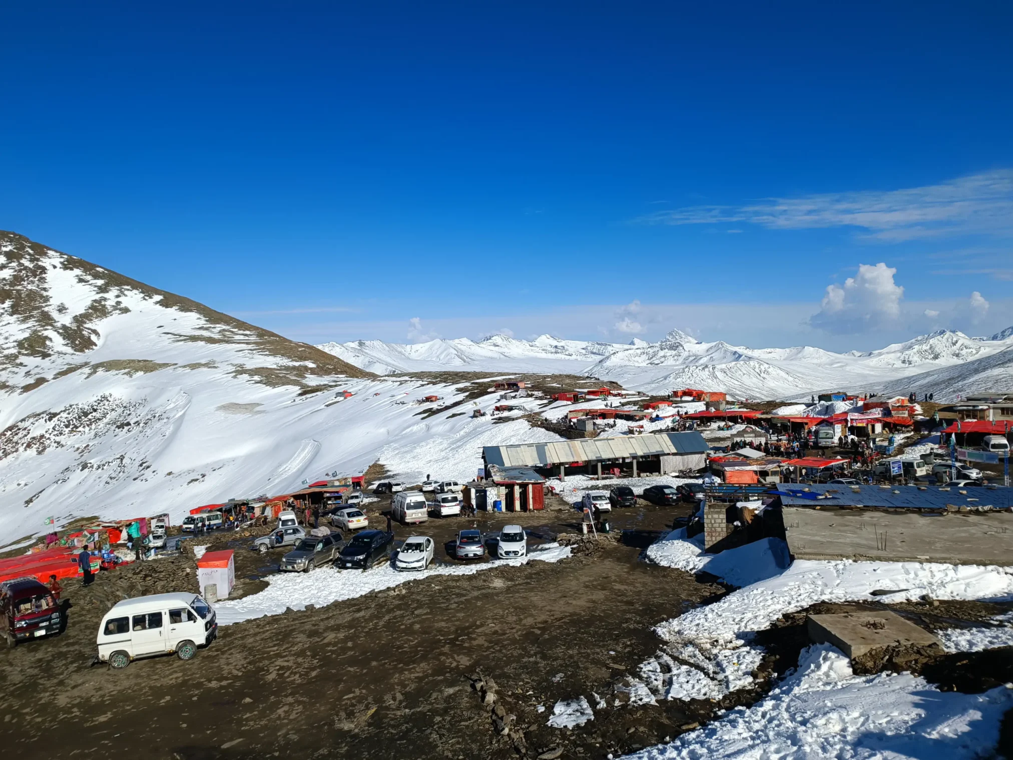
Traditional Roadside Cafés and Tea Stalls
Although Babusar Top lies at a very high altitude, small chai stalls and dhabas operate during the summer season. These stalls offer travelers a chance to rest while enjoying:
- hot tea
- snacks
- noodles
- parathas
Drinking a hot cup of tea while overlooking the vast mountains is one of the most enjoyable experiences for tourists.
Tourism and Local Economy
Tourism plays a major role in supporting the economy of Kaghan Valley. Local residents earn income through:
- hotels and guesthouses
- jeep rentals
- restaurants and cafés
- selling handicrafts
- guiding tourists
As more travelers discover the beauty of Babusar Top, tourism continues to grow in the region. However, experts also emphasize the need for sustainable tourism practices to protect the fragile mountain environment.
Google Visitor Reviews
⭐⭐⭐⭐⭐
“The people of Kaghan Valley were incredibly friendly. The local honey and trout fish were delicious.” — Tourist Review
⭐⭐⭐⭐⭐
“Watching shepherds grazing their sheep in the mountains felt like stepping into a different world.” — Nature Traveler
Travel Routes, Road Journey, Safety Tips, and Best Travel Itinerary
For many travelers, the road trip to Babusar Top is just as exciting as the destination itself. The journey through Kaghan Valley offers one of the most scenic drives in the country.
How to Reach Babusar Top
Babusar Top lies along the N-15 Highway, which connects Kaghan Valley with Chilas. Most travelers begin their journey from Islamabad, the nearest major city.
Route Overview
The typical route to Babusar Top is:
Islamabad → Balakot → Naran → Babusar Top → Chilas
Along this route, travelers experience dramatic changes in landscape — from green hills to alpine mountains.
Distance and Travel Time
Below are approximate travel distances to Babusar Top from major locations.
| Starting Point | Distance | Estimated Travel Time |
|---|---|---|
| Islamabad | 300 km | 8–9 hours |
| Naran | 70–120 km | 3–4 hours |
| Chilas | 130 km | 4–5 hours |
Travel time can vary depending on weather, traffic, and road conditions.
Road Journey from Islamabad
The journey from Islamabad begins on highways leading toward Mansehra. From there, travelers continue toward Balakot, which marks the entrance to Kaghan Valley. The road then climbs through scenic mountain areas before reaching Naran. Naran serves as the main tourist base for visitors exploring Babusar Top and nearby attractions.
Naran to Babusar Top Road Journey
The road from Naran to Babusar Top is one of the most breathtaking drives in Pakistan. Travelers encounter:
- glacier streams crossing the road
- lush alpine valleys
- winding mountain roads
- steep climbs and hairpin bends
- panoramic mountain views
Key stops along the way include:
- Batakundi
- Jhalkad
- Lulusar Lake
These scenic stops allow travelers to rest and enjoy the natural beauty of the region.
Road Conditions and Driving Challenges
Although the road to Babusar Top is paved, it presents several challenges.
Steep Slopes
The climb toward Babusar Pass includes steep mountain slopes that require careful driving.
Hairpin Bends
The road contains numerous sharp curves that demand slow and cautious driving.
Weather Conditions
Rain, fog, or snowfall can make the road slippery and reduce visibility.
Brake Failures
Due to steep descents, vehicles with poor brake conditions may face difficulties. Many reported accidents in the region occur because drivers underestimate the steep terrain.
Safety Tips for Travelers
When planning a trip to Babusar Top, travelers should follow these safety precautions:
1. Check Vehicle Condition
Ensure that your vehicle has:
- properly functioning brakes
- good tires
- sufficient fuel
Gas stations are limited beyond Naran.
2. Avoid Night Driving
Driving at night on mountain roads can be risky due to:
- low visibility
- lack of street lights
- wildlife crossing roads
It is safer to travel during daylight hours.
3. Carry Warm Clothing
Even in summer, temperatures at Babusar Top can be very cold.
Travelers should bring:
- jackets
- gloves
- warm hats
Weather conditions can change rapidly at high altitude.
4. Be Prepared for Altitude Sickness
At 4,173 meters, Babusar Top has significantly lower oxygen levels.
Some travelers may experience symptoms such as:
- headaches
- dizziness
- fatigue
To reduce the risk:
- stay hydrated
- move slowly
- avoid strenuous activity immediately upon arrival
5. Carry Emergency Supplies
It is always wise to bring:
- a first-aid kit
- drinking water
- snacks
- extra fuel if possible
Medical facilities are limited in high mountain areas.
Best Time to Visit Babusar Top
Due to heavy snowfall in winter, Babusar Top remains closed for several months each year.
Best Season: Summer (June – September)
During summer:
- roads are open
- weather is relatively mild
- tourism activities are at their peak
This period offers the best opportunity for sightseeing and photography.
Winter Conditions
In winter months:
- heavy snowfall blocks the road
- temperatures drop below freezing
- travel becomes extremely difficult
For this reason, most travelers visit Babusar Top during the summer season.
Babusar Top Weather
Babusar Top experiences extremely cold and unpredictable weather due to its high altitude (around 13,700 ft). The weather remains harsh for most of the year, with heavy snowfall, strong winds, and sudden changes in conditions. During winter, the entire region is covered in snow, making the pass inaccessible, while even in summer, clouds, fog, and chilly winds are common. Travelers often encounter rapidly shifting weather, where clear skies can turn into snowfall or rain within hours.
Babusar Top Temperature
The temperature at Babusar Top stays very low throughout the year. In winter, temperatures can drop as low as -10°C to -20°C, with freezing conditions dominating the region. Even in summer (June to September), daytime temperatures usually range between 5°C to 15°C, while nights can fall close to 0°C or below. Current conditions also show temperatures around freezing or below, highlighting how cold the area remains even outside peak winter months.
Suggested 3-Day Travel Itinerary
Day 1
Travel from Islamabad to Naran.
Explore local markets and rest overnight in Naran.
Day 2
Visit nearby attractions such as:
- Lake Saiful Malook
- Lulusar Lake
Continue the journey to Babusar Top and enjoy panoramic views.
Day 3
Drive toward Chilas or return to Islamabad.
Stop along the route to enjoy waterfalls and mountain scenery.
Environmental Challenges in the Babusar Region
The Babusar area, while breathtaking, faces several environmental challenges:
1. Glacier Melting
The glaciers feeding rivers and lakes in Kaghan Valley, including Lulusar Lake, are retreating due to climate change.
Consequences include:
- reduced water levels
- altered river flows
- impact on local biodiversity
2. Deforestation
Local timber collection and illegal logging affect forested areas like:
- Sharan Forest
- surrounding pine and oak forests
Deforestation leads to:
- soil erosion
- reduced wildlife habitat
- loss of natural beauty
3. Unplanned Road Construction
Rapid development and unregulated construction along roads to Babusar Top contribute to:
- landslides
- road erosion
- disruption of natural landscapes
Travelers are advised to stay alert during construction zones and respect local safety warnings.
4. Pollution and Waste
Increasing tourism can result in:
- litter along roads and meadows
- pollution in alpine lakes
- disturbance of wildlife
Visitors should carry back trash and use eco-friendly practices.
Conservation Efforts
To preserve Babusar Top and Kaghan Valley, several measures are being promoted:
- Eco-tourism Awareness
Encouraging visitors to respect wildlife and natural habitats. - Waste Management Programs
Local authorities have begun campaigns to reduce litter in tourist areas. - Community-Based Conservation
Involving local communities in protecting forests, lakes, and meadows. - Infrastructure Improvements
Developing safer roads while minimizing environmental impact.
Final Travel Tips for Babusar Top
To enjoy a safe and unforgettable visit, follow these tips:
- Visit between June and September for optimal weather.
- Hire local guides if unfamiliar with mountain roads.
- Carry warm clothes, first-aid kit, and snacks.
- Keep your vehicle in excellent condition, with full fuel.
- Avoid driving at night and during heavy rain or snow.
- Respect wildlife and forests; avoid littering.
- Take photographs responsibly, keeping distance from animals.
Recommended Itinerary Highlights
- Day 1: Islamabad → Naran; explore local markets and cafes.
- Day 2: Visit Lake Saiful Malook, Lulusar Lake, and Babusar Top.
- Day 3: Trek or jeep safari to Siri Paye Meadows or Lalazar Meadows; return via Naran.
- Optional extensions: Continue toward Chilas, Hunza, or Skardu for extended northern adventure.
Conclusion
Babusar Top offers an incredible mix of adventure, natural beauty, culture, and high-altitude experiences.
From snow-capped peaks, lush meadows, and glacial lakes to nomadic shepherds, local cuisine, and biodiversity, this destination is a complete travel experience.
By respecting nature, following safety tips, and planning your itinerary wisely, Babusar Top promises an unforgettable journey into the heart of Pakistan’s northern mountains
Frequently Asked Questions (FAQs) about Babusar Top
1. What is Babusar Top and where is it located?
Babusar Top is a high mountain pass situated at 4,173 m (13,691 ft) above sea level, linking the Kaghan Valley with Chilas in Gilgit‑Baltistan, Pakistan.
2. Is Babusar Top open right now?
The pass is seasonal. It typically opens from late May–June after winter snow clears and stays open through September, though closures can occur anytime due to weather.
3. When is the best time to visit Babusar Top?
June–September is widely recommended — the road is clearer, weather is milder, and landscapes are most scenic.
4. Is Babusar Top safe to visit?
Yes, but travel with caution. Road conditions can be slippery, weather unpredictable, and visibility poor during rains or snowfall. Authorities often issue advisories during bad weather
5. How do I know if the road is open?
Babusar Top road conditions depend on snowfall and maintenance. Locals, hotel staff in Naran, or the traffic police can provide the latest status before departure.
6. Can anyone drive there with any car?
Small cars can make the journey, but 4×4 vehicles or high‑power cars are recommended, especially in early season or tricky weather.
7. How far is Babusar Top from Naran and Islamabad?
From Naran it’s about 65–80 km and takes 1.5–3 hours by road. From Islamabad, it’s roughly 300–320 km with a travel time of around 8–10+ hours depending on stops.
8. Is there mobile network coverage at Babusar Top?
Signal coverage is limited and unreliable at high altitudes — partial coverage from few providers may be possible
9. Can I visit in winter?
It’s not recommended — heavy snowfall usually blocks the pass from late autumn to spring, making roads inaccessible.
10. Are accommodations available near the top?
There are no proper hotels at Babusar Top itself, but stays are available in Naran, Batakundi, and Jhalkad before the pass.
11. What should I pack for Babusar Top?
Bring:
- Warm layered clothing
- First‑aid essentials
- Plenty of water & snacks
- Extra fuel (limited filling stations)
- Power banks and rain gear
12. What are popular activities there?
Sightseeing, photography, short walks, stargazing, birdwatching, and scenic picnics are common.
13. Why does Babusar Top close in winter?
Heavy snow and treacherous road conditions make travel dangerous; authorities close the route until safe again
14. Is altitude sickness a concern?
Yes — at over 4,000 m you may experience headaches, dizziness, or nausea. Move slowly, hydrate, and rest to help acclimatize.
15. Are there alternate routes if Babusar Top is closed?
If Babusar is shut, travelers headed to Gilgit‑Baltistan usually use the Besham–Dasu–Chilas route via Karakoram Highway, which remains open year‑round.


