Miranjani Weather Widget – Complete Guide
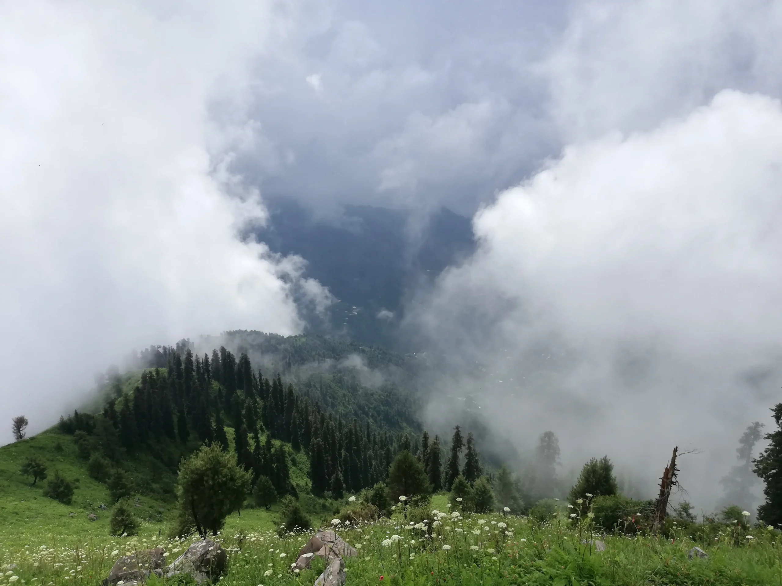
The Miranjani Top Weather Widget is a high-altitude trekking companion designed specifically for the rugged and scenic terrain of the Galiyat region. By pulling real-time meteorological data directly from the summit’s coordinates, it delivers an accurate snapshot of the Miranjani Top temperature, wind speed, UV exposure, and visibility at an elevation of nearly 2,992 meters.
What sets this widget apart is its intelligent “Hiker’s Advisory” system, which translates raw weather data into practical trekking guidance. Whether the trail is dry and clear, slippery due to rainfall, or covered in snow requiring gear like crampons and trekking poles, hikers receive instant, actionable insights before and during their ascent.
Beyond the basics, the Weather in Miranjani Top widget includes a smooth, mobile-friendly hourly trekking forecast slider and a 5-day outlook, helping trekkers plan their climb for optimal weather conditions. On clear days, this ensures the best chance to experience breathtaking panoramic views of the Himalayan foothills, Abbottabad valley, and surrounding pine forests.
Built with a clean, high-contrast interface, the widget supports both light and dark modes, ensuring excellent readability whether you’re under bright alpine sunlight or hiking through shaded forest trails. For adventurers starting from Nathia Gali or trekking deeper into Ayubia National Park, this tool becomes an essential part of a safe and well-timed expedition.
Miranjani Weather: FAQ
1. What is the total height of Miranjani Top?
Miranjani Top stands at approximately 2,992 meters (9,816 feet) above sea level, making it the highest peak in the Galiyat region.
2. How long does the trek take?
The trek usually takes:
- 2.5 to 4 hours uphill
- 2 to 3 hours downhill
depending on fitness level, weather, and trail conditions.
3. Which route is best for Miranjani?
The most popular route is:
- Nathia Gali → Governor House → Miranjani Trail
This route is:
- Well-marked
- Scenic with dense pine forests
- Moderately challenging
4. Is the trek difficult?
Miranjani is considered moderate to slightly challenging:
- Longer than Mushkpuri
- Gradual but continuous incline
- Final stretch is steeper and more demanding
5. Is the trek safe for beginners?
Yes, but with caution:
- Beginners can complete it with steady pacing
- Not ideal for very young children or elderly without preparation
- Weather conditions can significantly impact difficulty
6. Can I visit Miranjani in winter?
Yes — but it becomes a snow trek:
- Heavy snow from December to March
- Slippery trails and freezing temperatures
- Requires proper gear like:
- Crampons
- Waterproof boots
- Thermal layers
7. Is there mobile network coverage?
Yes, but inconsistent:
- Signals available at higher elevations and the top
- Weak or no signal inside dense forest sections
8. Are there dangerous animals on the trail?
The trail lies within Ayubia National Park, home to:
- Leopards (rare, nocturnal)
- Monkeys
Safety tips:
- Avoid trekking after sunset
- Stay in groups
- Do not carry exposed food
9. Is food or water available on the trail?
No. You must carry:
- At least 1.5–2 liters of water per person
- Energy snacks (nuts, dates, protein bars)
10. Is camping allowed at Miranjani Top?
Camping is generally not recommended due to:
- Wildlife risks
- Lack of facilities
- Sudden weather changes
Most hikers complete it as a day trek.
11. Do I need a guide?
Not necessary for the main trail because:
- Path is clearly marked
- Frequently used by hikers
However, a guide is helpful if:
- Trekking in snow
- Exploring off-trail routes
12. What should I pack?
Essentials include:
- Durable hiking shoes
- Warm jacket / windbreaker
- Hiking stick
- Sunscreen & sunglasses
- Water & snacks
13. Are horses available?
Horse services are less common than Mushkpuri, but may be available near Nathia Gali.
14. What can I see from the top?
On a clear day, you can enjoy:
- 360° panoramic views
- Abbottabad valley
- Kashmir hills
- Pine forest landscapes
15. What is the best time to visit?
- Spring (April–June): Pleasant weather
- Monsoon (July–September): Lush greenery, but slippery trails
- Autumn (October): Clear skies, best views
- Winter (Dec–March): Snow trekking (advanced hikers only)
Final Note
Miranjani isn’t just a hike—it’s a full alpine experience that demands both physical endurance and thoughtful preparation. Rising to an elevation of nearly 3,000 meters, it stands as the highest peak in the Galiyat region, offering not only breathtaking panoramic views but also a dynamic environment where weather conditions can shift rapidly. Unlike shorter, more forgiving trails, Miranjani presents a longer and more immersive journey through dense pine forests, gradually opening into high-altitude ridges where wind, temperature, and visibility become critical factors in shaping the trekking experience.
What makes Miranjani particularly unique is this constant interaction between terrain and climate. A trek that begins under clear blue skies in Nathia Gali can quickly transition into mist-covered pathways, strong winds, or even unexpected rainfall as you gain elevation. In winter months, the same trail transforms entirely—snow blankets the path, temperatures drop significantly, and sections become slippery and technically challenging. Even in summer, the high altitude ensures cooler air, strong UV exposure, and occasional cloud build-up that can reduce visibility near the summit. This variability makes planning not just helpful, but essential.
This is where the Miranjani Weather Widget becomes more than just a convenience—it becomes a critical decision-making tool. Rather than relying on generic city-level forecasts, the widget pulls real-time weather data directly from the summit’s coordinates. This means hikers are getting precise insights into conditions exactly where they matter most: at the top and along the trail. Temperature readings reflect actual summit conditions, not nearby towns. Wind speeds indicate how harsh the environment might feel at exposed ridgelines. Visibility data helps determine whether you’ll be rewarded with clear views or surrounded by dense fog.
More importantly, the widget transforms complex meteorological data into simple, actionable guidance through its “Hiker’s Advisory” system. For many trekkers, especially beginners, interpreting raw weather metrics can be confusing. The widget removes that barrier by clearly indicating whether the trail is safe, slippery, or potentially hazardous. If rain has recently affected the area, it alerts you to muddy and unstable paths. If snowfall is detected, it signals the need for proper gear like crampons and insulated boots. High wind warnings help hikers avoid risky summit exposure, especially near open edges.
Beyond immediate safety, the widget also enhances the overall trekking experience through its planning features. The hourly forecast slider allows hikers to time their ascent strategically—starting early to avoid midday sun, or planning to reach the summit during peak visibility hours. The 5-day forecast adds another layer of foresight, helping trekkers choose the best possible day for their hike. This is especially valuable for travelers coming from cities like Islamabad or Lahore, where planning a trip around weather windows can make the difference between an average hike and an unforgettable one.
In essence, the Miranjani Weather Widget bridges the gap between raw environmental data and real-world trekking decisions. It empowers hikers with clarity, confidence, and control—turning uncertainty into informed action. Whether you’re a seasoned trekker chasing clear summit views or a first-time hiker aiming for a safe and enjoyable experience, this tool ensures that every step you take is backed by real-time intelligence. In a landscape as beautiful and unpredictable as Miranjani, that kind of insight isn’t just helpful—it’s indispensable.


