Babusar Top Weather widget is a customized, real-time weather monitoring tool designed specifically for the extreme conditions of Babusar Top. By pulling live data from high elevation, it provides travelers with a high-precision look at the current Babusar Top temperature, wind speed, and visibility at 4,173 meters. The inclusion of a dynamic “Traveler’s Summary” bridges the gap between complex data and practical advice, instantly informing users whether the pass is safe for standard vehicles or if specialized equipment like snow chains and 4×4 capability is required.
Beyond current stats, the widget, Weather in Babusar Top features a sleek, mobile-responsive hourly slider and a 5-day forecast to help tour planners time their crossing during the safest daylight hours. Designed with a clean aesthetic, it supports both light and dark modes to ensure readability in the harsh glare of mountain sunlight or the dim cabin of a vehicle. This makes it an essential digital companion for anyone navigating the high-altitude link between the Kaghan Valley and Gilgit-Baltistan.
Babusar Top Weather & Babusar Top Temperature: FAQ
1. What is the typical Babusar Top temperature in summer? Even in the peak of summer (June to August), Babusar Top temperature is low and remains quite chilly. Daytime Babusar Top temperatures usually range between 5°C and 15°C, while nights often drop near or below freezing (0°C to -5°C). July is typically the warmest month, but a jacket is necessary regardless of the time of day.
2. When does the Babusar Pass officially open and close? The pass is seasonal. It generally opens in mid-June once the National Highway Authority (NHA) clears the heavy winter snow. It typically closes by late October or early November after the first major autumn snowfall. For 2026, it is currently closed and expected to reopen in June.
3. Is it safe to drive to the top during the monsoon (July-August)? While the pass is open, the monsoon season brings a high risk of landslides and flash floods along the Naran-Babusar road. Always check the live precipitation and visibility data in the widget before departing from Naran or Chilas, as conditions can change in minutes.
4. Why does the “Feels Like” temperature differ so much from the actual temp? At an altitude of over 13,000 feet, the air is thin, and wind speeds are higher. The wind chill factor significantly lowers the perceived temperature. If the actual Babusar Top temperature is 10°C but the wind is blowing at 30 km/h, it can feel like 2°C or lower on exposed skin.
5. Do I need a special vehicle to visit Babusar Top? When the road is fully cleared in mid-summer, most well-maintained cars can make the climb. However, 4×4 vehicles or high-clearance SUVs are highly recommended, especially early in the season (June) or late (October) when the road can be slippery due to melting glaciers or fresh slush.
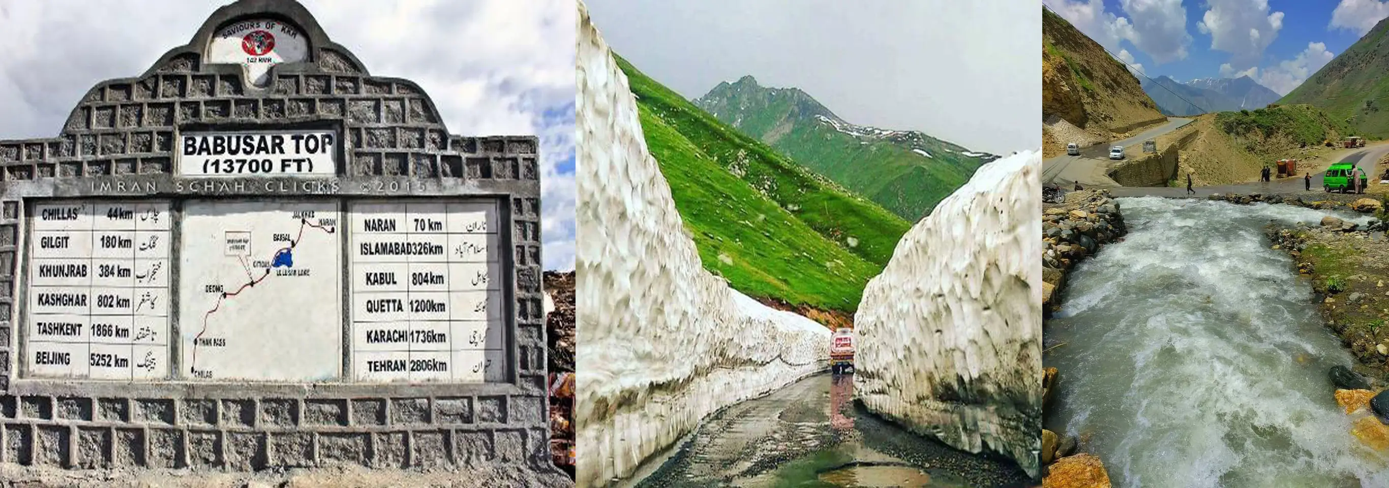
6. Where is Babusar Top located? Babusar Top is located in the northern region of Pakistan, connecting Kaghan Valley with Chilas via the famous Babusar Pass.
7. What is the altitude of Babusar Top? Babusar Top stands at an impressive height of approximately 4,173 meters (13,691 feet) above sea level, making it one of the highest drivable mountain passes in Pakistan.
8. How long does it take to reach Babusar Top from Naran? From Naran, it usually takes 2.5 to 3.5 hours, depending on road conditions, traffic, and weather.
9. Is snowfall common at Babusar Top? Yes, snowfall is extremely common. Even during early summer (June), you may still see snow along the roadside. Heavy snowfall in winter completely blocks the pass.
10. Are there food and restroom facilities available? Basic facilities like small cafes and tea stalls are available during the open season. However, options are limited, so it’s best to carry snacks and water.
11. Is Babusar Top suitable for family trips? Yes, Babusar Top is a popular destination for families. However, due to high altitude and cold weather, elderly people and young children should be monitored carefully.
12. Can we stay overnight at Babusar Top weather conditions? No, overnight stays at Babusar Top are not recommended due to extreme cold, lack of accommodation, and strong winds. It’s better to stay in Naran or nearby areas.
13. What should I pack for a trip to Babusar Top? Essential items include:
- Warm jackets and gloves
- Comfortable shoes
- Sunglasses and sunscreen
- Snacks and water
- Power bank and emergency kit
14. Is mobile network coverage available at Babusar Top? Mobile signals are weak or unavailable at the top. Some coverage may be available in areas near Naran.
15. What are the best months to visit Babusar Top? The ideal time to visit is between late June and September, when the road is open and weather conditions are relatively stable
For a visual guide on the journey and current road conditions, you can check out this Babusar Top Travel Update and the weather in Babusar Top.


%205-Day%20Forecast%20Traveler’s%20Summary:%20Getting%20current%20advice%20for%20the%20pass…%20Babusar%20Top%20Weather%20widget%20is%20a%20customized,%20real-time%20weather%20monitoring%20%5B…%5D&media=https://nigarcraft.com.pk/wp-content/uploads/2026/03/Babusar-Top-Weather.webp)