Region: Azad Jammu & Kashmir, Pakistan
District Headquarters: Mirpur City
Main Postal Code: 10250 (Mirpur GPO) – General Post Office for Mirpur town
Postal codes in Azad Kashmir are five-digit numbers used by Pakistan Post for sorting, routing, and delivering mail efficiently.
Includes both delivery post offices and branch or locality codes for the Mirpur District.
- Azad Kashmir Postal codes are five digits and are essential for accurate mail and parcel delivery in Islamabad, Rawalpindi, Lahore, or elsewhere in Pakistan.
- Main post office for the district is Mirpur GPO (10250), with other areas using localized codes.
Mirpur Azad Kashmir Postal Codes List
| NAME OF DELIVERY POST OFFICE | POST CODE | ACCOUNT OFFICE | PROVINCE | BRANCH OFFICES |
| AFZAL PUR | 10360 | Mirpur GPO | Azad Kashmir | 10361 |
| AJK BOARD OF EDUCATION MIRPUR | 10240 | Mirpur GPO | Azad Kashmir | 10241 |
| AKAL GARH | 10470 | Mirpur GPO | Azad Kashmir | 10471 |
| BANNI | 10370 | Mirpur GPO | Azad Kashmir | 10371 |
| BEHARI | 10534 | Mirpur GPO | Azad Kashmir | 10535 |
| BOHA DHANGRI | 10490 | Mirpur GPO | Azad Kashmir | 10491 |
| BONG COLONY | 10210 | Mirpur GPO | Azad Kashmir | 10211 |
| CHAK SAWARI | 10500 | Mirpur GPO | Azad Kashmir | 10501 |
| CHECHIAN | 10350 | Mirpur GPO | Azad Kashmir | 10351 |
| CHHANI REKI | 10404 | Mirpur GPO | Azad Kashmir | 10405 |
| CHHATTROH | 10320 | Mirpur GPO | Azad Kashmir | 10321 |
| CHITTER PARI | 10230 | Mirpur GPO | Azad Kashmir | 10231 |
| DADYAL KHURD | 10530 | Mirpur GPO | Azad Kashmir | 10531 |
| DHAMAWA | 10460 | Mirpur GPO | Azad Kashmir | 10461 |
| JARI KASS | 10232 | Mirpur GPO | Azad Kashmir | 10233 |
| JATLI (AK) | 10380 | Mirpur GPO | Azad Kashmir | 10381 |
| JATTI DHERI | 10480 | Mirpur GPO | Azad Kashmir | 10481 |
| KALRI | 10382 | Mirpur GPO | Azad Kashmir | 10383 |
| KATHA DILAWAR KHAN | 10550 | Mirpur GPO | Azad Kashmir | 10551 |
| KHADIMABAD | 10310 | Mirpur GPO | Azad Kashmir | 10311 |
| MANGLA DAM | 10200 | Mirpur GPO | Azad Kashmir | 10201 |
| MIRPUR GPO | 10250 | Mirpur GPO | Azad Kashmir | 10251 |
| PALAK | 10520 | Mirpur GPO | Azad Kashmir | 10521 |
| PANJERI | 10400 | Mirpur GPO | Azad Kashmir | 10401 |
| PIND KALAN | 10510 | Mirpur GPO | Azad Kashmir | 10511 |
| POTHA BAINSI | 10450 | Mirpur GPO | Azad Kashmir | 10451 |
| RATTA | 10540 | Mirpur GPO | Azad Kashmir | 10541 |
| SIAKH | 10300 | Mirpur GPO | Azad Kashmir | 10301 |
| TARIQ ABAD (MIRPUR) | 10390 | Mirpur GPO | Azad Kashmir | 10391 |
| THARA | 10544 | Mirpur GPO | Azad Kashmir | 10545 |
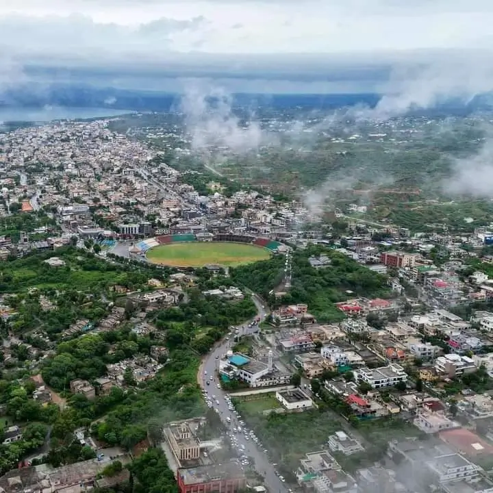
Location & Status – Mirpur Azad Kashmir
Mirpur is a major city and the administrative headquarters of Mirpur District in Azad Jammu & Kashmir (AJK). It is located in the southern part of AJK and lies approximately 25 km from Jhelum (Punjab, Pakistan), about 100 km from Islamabad, and roughly 200 km from Lahore.
Due to its proximity to Punjab and its large overseas community, Mirpur is often referred to as “Little England.”
Population – Mirpur Azad Kashmir
Mirpur City (Town)
Population (2017 Census): ~124,000 residents
Mirpur City is one of the largest urban centers in Azad Jammu & Kashmir.
Mirpur Azad Kashmir District
Total district population (2017): ~456,000 people
The district population includes Mirpur city, Dadyal, Islamgarh, and surrounding rural areas and villages.
Administrative Structure – Mirpur Azad Kashmir
District Status
Mirpur is one of the 10 districts of Azad Jammu & Kashmir and serves as an important political and administrative center in southern AJK.
Tehsils in Mirpur Azad Kashmir District:
- Mirpur Tehsil
- Dadyal Tehsil
- Islamgarh Tehsil
These tehsils oversee local governance, union councils, municipal services, and regional administration.
Geography & Background – Mirpur Azad Kashmir
Area
Approximately 1,010 square kilometres
Terrain
- Semi-hilly landscape
- Plains near Punjab border
- Mangla Dam reservoir surroundings
Climate
- Hot summers
- Mild to cool winters
- Moderate rainfall
Historical Background – Mirpur Azad Kashmir
Mirpur has historically been an important settlement due to its strategic location near Punjab and key trade routes connecting Kashmir with the plains. Before 1947, Mirpur was part of the princely state of Jammu and Kashmir under Dogra rule.
During the events surrounding the Partition of the subcontinent in 1947, Mirpur witnessed major political and demographic changes. Afterward, it became part of Azad Jammu & Kashmir.
A significant turning point in Mirpur’s history came in the 1960s with the construction of Mangla Dam on the Jhelum River. The dam project led to the relocation of old Mirpur city and the development of New Mirpur City. Many residents migrated to the United Kingdom during this period, establishing a large overseas community.
Over time, Mirpur developed into one of the most modern and economically active cities in AJK, supported heavily by overseas remittances and infrastructure development.
Languages & Culture – Mirpur Azad Kashmir
Widely Spoken Languages:
- Pahari-Pothwari
- Punjabi
- Gojri
- English (commonly spoken due to overseas connections)
Official Language:
- Urdu
Mirpur has a strong cultural identity shaped by Kashmiri traditions and British-Pakistani influences. Weddings, festivals, and community events often reflect both local customs and overseas cultural exposure.
Daily Life & Economy – Mirpur Azad Kashmir
Mirpur’s economy is supported by:
- Remittances from overseas Pakistanis (especially the UK)
- Trade and small businesses
- Real estate and construction
- Agriculture (wheat, maize, vegetables)
- Mangla Dam-related economic activity
- Education sector (colleges and universities)
Due to high overseas investment, Mirpur is considered one of the most developed cities in Azad Kashmir, with modern housing societies, shopping areas, and improved infrastructure.
Despite its semi-hilly geography, Mirpur plays a central economic, political, and social role in southern Azad Jammu & Kashmir.
Frequently Asked Questions (FAQs) – Mirpur Azad Kashmir
1. Where is Mirpur located?
Mirpur is located in the southern part of Azad Jammu & Kashmir (AJK), Pakistan. It lies near the Punjab border, approximately 25 km from Jhelum, 100 km from Islamabad, and around 200 km from Lahore.
2. What is the population of Mirpur?
According to the 2017 Census:
- Mirpur City population: Approximately 124,000 residents
- Mirpur District population: Around 456,000 people
3. Why is Mirpur called “Little England”?
Mirpur is called “Little England” because a large number of its residents have migrated to the United Kingdom. Many families receive remittances from abroad, and British cultural influence is visible in housing, lifestyle, and language.
4. How many tehsils are in Mirpur District?
Mirpur District has three tehsils:
- Mirpur Tehsil
- Dadyal Tehsil
- Islamgarh Tehsil
5. What is Mirpur famous for?
Mirpur is famous for:
- Mangla Dam
- Overseas Kashmiri community (especially in the UK)
- Modern housing societies
- Trade and remittance-based economy
6. What languages are spoken in Mirpur?
The widely spoken languages in Mirpur include:
- Pahari-Pothwari
- Punjabi
- Gojri
- Urdu (official language)
- English (commonly used due to overseas connections)
7. What is the climate like in Mirpur?
Mirpur has:
- Hot summers
- Mild to cool winters
- Moderate rainfall throughout the year
8. What is the main source of income in Mirpur?
The primary economic drivers of Mirpur include:
- Overseas remittances (mainly from the UK)
- Real estate and construction
- Small businesses and trade
- Agriculture
- Mangla Dam-related activities
9. Is Mirpur a developed city in AJK?
Yes, Mirpur is considered one of the most developed and modern cities in Azad Jammu & Kashmir due to strong overseas investment and infrastructure growth.
10. What is the historical importance of Mirpur?
Mirpur was historically part of the princely state of Jammu and Kashmir. After 1947, it became part of Azad Jammu & Kashmir. The construction of Mangla Dam in the 1960s significantly shaped its modern development and migration patterns.


%20–%20General%20Post%20Office%20for%20Mirpur%20town%20Postal%20codes%20in%20Azad%20Kashmir%20are%20five-digit%20numbers%20used%20by%20Pakistan%20Post%20for%20sorting,%20routing,%20and%20delivering%20mail%20efficiently.%20Includes%20both%20delivery%20post%20offices%20and%20branch%20or%20locality%20codes%20for%20the%20Mirpur%20District.%20Mirpur%20%5B…%5D&media=https://nigarcraft.com.pk/wp-content/uploads/2026/02/Mirpur-Azad-Kashmir-Postal-Code.webp)